02.09.09
Posted in Maps, Politics at 4:11 pm by ducky
I have added the 2004 presidential election results to my politics/demographics map. Loading that data also let me provide a map of the difference between the 2004 and 2008 election:
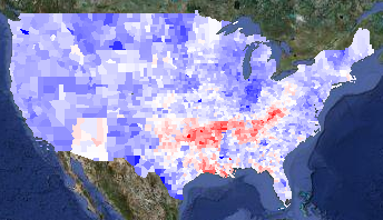
2008 v. 2004 presidential election results
The map is red in counties that voted more Republican in 2008 and blue for counties that voted more Democratic. I think it is interesting that Arizona — McCain’s home state — pops out very clearly, while Illinois does not.
Anthony Robinson did a heroic job pulling out all the 2004 data, but there were a lot of problems with the data. I presume he had to work with preliminary data, while I could get final data. I scraped information from AZ, CA, GA, IN, LA, MO, NC, NY, TX, and VA, so I have high confidence in those states. I want to look a little more closely at Illinois — I need to be in Windows to get at that data, ugh. Alaska is a pain because it is done by house district and not by county, so I will get that in a little later.
A friend of mine had seen a similar map in the New York Times, and was surprised that Louisiana was so red. He thought that it was odd that, given the snafus after Katrina, it would have been strongly anti-Republican. I thought perhaps the data was just incorrect, but no — I verified the Louisiana data. My best guess is that the white people outside New Orleans saw a lot of images about people behaving badly in New Orleans in the Katrina aftermath. Those people were predominantly black, and I can believe that the white people nearby associated bad behaviour with “black people” instead of with “desperate poor people” or “strung-out drug addicts without a fix” or even “criminals”. They might be more inclined to vote against Obama for being black.
I actually find Oklahoma odder: Oklahoma has a relatively high percentage of Native Americans. In many places, they voted very strongly for Obama. Not in Oklahoma, they didn’t.
I also added information on governors’ and senators’ party affiliations because it was really easy to do so.
Update1: Looking at the red zones, I notice that there are very hard edges on the redness at the northern boundaries of Arkansas and Tennesee. Perhaps it isn’t really that Obama did particularly poorly there, but that Kerry did particularly well, perhaps by association with Arkansan Bill Clinton and Tenneseean Al Gore? It would be interesting to compare Obama’s margins with Jimmy Carter’s, but I don’t think it will be easy to get the 1976 election results by county.
Update2: I did find better data — all the way back to 1960! I blogged about it.
Update3: I found someone in Oklahoma. He said that Oklahoma has a low educational level, and that while many people claimed Native heritage, many of the people were only a minority Native, and were culturally white.
Permalink
02.08.09
Posted in Maps, Politics at 5:23 pm by ducky
I made a new map of where the stimulus spending was forecast to go. I pulled the data from the White House Web site a few days ago, so note that it is for the proposed stimulus bill, not the bill as it passed. Also, it shows per capita amounts, using 2006 population figures from Wikipedia, so there will be a minor error due to the years being different.
I didn’t make a lot of noise about this one because I hope to do another, better one when the numbers are more stable.
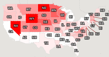
Jobs created or saved per capita
Permalink
02.01.09
Posted in Maps at 11:46 am by ducky
I made a demo of my new mapping framework, a choropleth map of the 2008 presidential election that you can combine with various demographic layers, zoom in, zoom out, change the colour mapping, and all kinds of good things.
The base layer is a map of the election results by county. Here it is with all the controls clipped off:
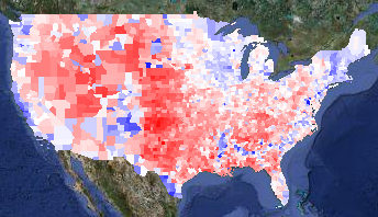
Voting margin layer
Blue counties are ones where more people voted for Obama; red counties voted for McCain. The intensity of the colour shows how big the spread between the two candidates was. Counties are white if the race was close.
A liberal friend of mine said with some dismay, “That’s an awful lot of red!” That’s true, but most of those red counties have very few people in them. One way to get a sense of how few people live in the center of the country is to overlay ZIP code locations (presumably the centers of the ZIP codes):
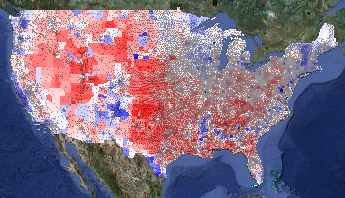
Voting layer with ZIP codes overlay
(The ZIP layer is even more interesting in bigger images. I’m showing cropped, tiny versions of the map; you can select medium and huge sizes too.)
Another way to see the population density is to overlay the population density layer on top of the voting layer. I set the population density layer to go from full white at zero people per square mile to full green at 400 people per square mile:
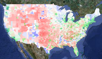
Voting layer plus population density overlay
Note that 400 people per square mile is still very, very low compared to urban areas. (New York City has around 50,000 people per square mile. Some census tracts in San Francisco have around 200,000 people per square mile; San Quentin has a density of 250,000 people per square mile.) I recommend playing with the colour mapping to get a sense of how dramatically unevenly the country is populated.
The next thing to look at is where the Obama voters were. In addition to urban areas, racially diverse areas went for Obama pretty stunningly consistently. If you lay the percent-White layer on top of the voting layer, it is really striking how often the blue of an Obama county coincides with the white of a low-percent-White county. In the percent-White overlay in this map, full white corresponds to 70% of the population or less being White, while full green corresponds to 100% White:
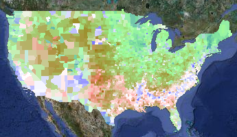
Voting layer plus percent-White overlay
You can see that the West Coast and the South are more racially diverse, as well as some odd, isolated islands of blue in the middle of the country — mostly in the Mountain time zone. What are those odd blocks?
Those isolated patches of high-Obama, low-White correlate with Native American population. Here is a map of the percent-Native, with full white corresponding to 70% Native population and full green corresponding to 100% Native population. (I turned off the voting layer in the next picture.)
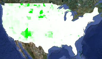
Percent Native American Layer
Not every place with a high Native population went for Obama. For example, Oklahoma has a high Native population, but Oklahoma went for McCain pretty reliably.
The sharp-eyed viewer will note a few blue counties in Idaho, Montana, and Wyoming that do not have a high percentage of Native Americans. These are the urban areas of Butte and Missoula, plus the resort areas of Sun Valley and Jackson Hole.
A prominent feature on the electoral layer is the blue crescent in the South. That corresponds neatly with high concentrations of African-Americans. On the demographic layer on this map, full white corresponds to 0% African-American and full green corresponds to 50% African-American:
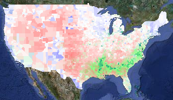
Voting layer plus percent Black layer
You can see correlation between Latino populations and Obama voters, although it isn’t as strong a correlation as elsewhere. In the demographic layer of the map below, full white is 0% Latino and full green is 50% Latino:
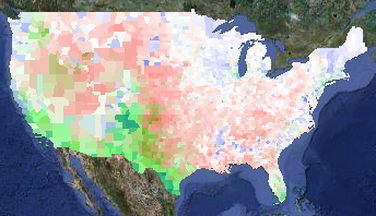
Voting layer plus percent Latino layer
Finally, there are some pale counties in the Midwest that are surrounded by red counties. I haven’t looked at each and every one, but I think they are college towns. Here’s a zoomed-in overlay of median age over the voting layer, with full white corresponding to a median age of 25 and full green to a median age of 45:
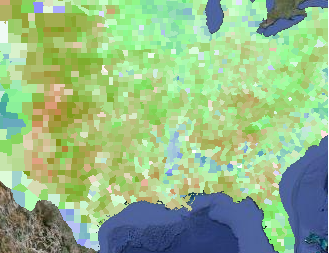
Voting layer plus median age layer
The areas that voted for Obama that can’t be explained by population density, racial diversity, or college towns are the upper midwest (e.g. Minnesota, Wisconsin, and Iowa) and the upper Northeast (e.g. Maine and Vermont). Obama spent a lot of time in Iowa, but I guess the others are just intrinsically liberal.
I also have point-based overlays for locations of Walmarts and health food stores. During the campaign, Fivethirtyeight.com talked frequently talked about the Walmart-to-Starbucks ratio, so I wanted to show those. Unfortunately, although I found a database of Starbucks locations, I wasn’t able to get permission to use it on my maps. (It’s a pity, because Starbucks locations seemed to correlate very well with Obama votes.) I bought data of Walmart locations and health food stores (figuring that health food stores would be a squishy liberal kind of thing) but eyeballing the data didn’t really convince me there was a correlation. But you can go try it out for yourself.
You can also see the locations of all 756 Native / Alaskan / Hawai’ian reservations from the dots layer.
Finally, I have a layer that shows the total votes (Obama + McCain + everyone else) divided by the population. I don’t know how much to trust this layer, as the demographic data I have is from the 2000 census. Areas that gained or lost a lot of people in the past eight years will be skewed. While the demographic data in all the demographic layers will be slightly off, it will be worse for this layer, especially in counties that don’t have a lot of people. (Loving County, TX, had 79 presidential votes in 2008 but only 67 total population in 2000.) Rural counties tend to have more land area than urban counties, so visually they will be overrepresented.
I encourage you to go play with the maps. In particular, I had to use zoom level 3 in order to get maps that would fit on my blog, but you lose a lot of detail and information. Also, when you aren’t worrying about running afoul of Google’s copyrights, you can let the map layer peek through to give you more context for what you are seeing.
Enjoy!
Permalink
01.30.09
Posted in Random thoughts at 8:33 pm by ducky
In an article for Slate, Daniel Gross points out that the Davos attendees, who are quick to lionize Great Men (yes, usually men) when there are big successes, are blaming the system now that things are going wrong.
I am not at all surprised. As I have blogged before, Larissa Tieden’s research shows that people think that high-status people do good things and that low-status people do bad things. In this context, low-status people are not powerful people who do bad things, but the invisible, the drones, the unseen — the system.
In this case, it is rather obvious that many, many people were complicit in the financial collapse: from those who made financial policy, to those who perpetuated the policy, to those who made bad deals, to those who took risky deals. I don’t find fault with saying that the system caused the failure.
I do think that we under-recognize how many people are “complicit” in successes. While it might be tempting to say that Google’s success, for example, was the success of the Great Men Larry Page and Sergey Brin, perhaps it really was the system: the fertile technical environment, the fertile financial environment, the fertile educational environment, the hard work of many early employees, and so on.
This doesn’t even factor in all the people who were positive influences on the people involved prior to Google’s birth. For example, their early, key employees were alive, while in other times and places not all of them would have survived to adulthood. The entire health care system — consisting of surgeons, doctors, epidemiologists, vaccine producers, hospitals, clinics, and insurance bureaucrats — were thus important. It’s the system.
If the Davos attendees really recognizes the importance of all the other people in any success, and by extension in their success, it would probably be harder for them be comfortable about their wealth and power.
Permalink
01.28.09
Posted in Random thoughts at 9:00 am by ducky
I have been struck and somewhat puzzled by how happy my friends’ dogs have been to see me. My old housemates’ dogs, for example, would get all excited to see me, even after a gap of several years.
I realized last weekend that the dog has no idea where I’ve gone, when I am coming back, or even if I am ever coming back. It must be like someone going off on a sailing ship 200 years ago: no idea where they are, when they will come back, or even if they will come back.
Permalink
01.22.09
Posted in Politics at 12:06 pm by ducky
From time to time since the election, I have burst into tears. Oftentimes it hits me without warning.
Today, I burst into tears twice. The first was at seeing a picture of Tommie Smith, John Carlos, and their wives in a group hug with Obama’s inauguration on the TV in the background. Tommie Smith and John Carlos were the two who gave the “black power” salute on the podium at the 1968 Olympic Games. That picture really gave me a sense that we have closed a chapter in our national history. The story of racism in the United States has not ended, but a chapter has closed. Slammed shut.
The second time, I could only eke out a “Honey!” Jim asked what, but I couldn’t answer because I was convulsed with sobs. Jim rushed to me, concerned. All I could manage was, “He signed it!” and point at the article saying that Obama had signed an anti-torture executive order. Thank you, Mr. President. I have been waiting for this for a long time.
Permalink
01.20.09
Posted in Gay rights, Politics at 4:56 pm by ducky
Watching the inauguration today, I couldn’t help but be reminded of gay pride parades.
There are very few mass events where everybody is really happy. Most large gatherings are sporting events, and there is almost always an undercurrent of hostility somewhere. If nothing else, the losing team’s fans are unhappy — usually. (I went to the 1994 Men’s World Cup match between the US and Brazil. Everybody knew that the Brazilians were way better than the USA, so in this case, the losers didn’t care that they were losing. Furthermore, it was the Brazilians! Their spirit of joy and fun was infectious.)
Maybe rock concerts are also places of fun sometimes, but I never had much fun at rock concerts. The band was always too far away to see and yet too loud.
The C-SPAN feed of the inauguration didn’t have any commentary, but instead just broadcast the ambient noise of the crowd. For two miles, almost all you could hear was people screaming their heads off as the motorcade (and microphone) moved down the route.
Ten years ago, when I marched in the SF Pride Parade with PFLAG, I experienced two miles of people cheering their hearts out. The straight public was not as accepting of gay and lesbian people back then, and thus (I guess) it meant a lot to see straight people standing up for gay rights. So they cheered.
In recent years, the cheers for PFLAG have been polite, but not overwhelming like before. That’s a good thing — that means that public acceptance is greater, so PFLAG isn’t as needed. The cheers for PFLAG were a reflection of how bad things were elsewhere, and how PFLAG represented a beacon of hope. It is a very good sign that the cheers for PFLAG are tamer now.
Similarly, the cheers for Obama reflected how bad things were. It would not have been so moving for African-Americans if African-Americans had not faced such brutal ill-treatment in the US. It would not have been so moving for me, a white person, if I had thought that G. W. Bush had done a competent job.
I hope that at the inauguration of the next non-white president, the crowds are much smaller and tamer.
Postscript: Apparently there were exactly zero arrests at the inauguration. I once asked a cop at the SF Pride Parade what it was like to work the parade. His answer: “Four hundred thousand people, no arrests, no injuries, what’s not to like?” (I had just gotten off of my shift as a Safety Monitor, and had first-hand knowledge that “no injuries” was a sligh exaggeration, but the injuries were all very mild — e.g. people skinning their knees, not e.g. getting beaten, hit by cars, falling 30 feet, etc.)
Permalink
Posted in Politics at 1:59 pm by ducky
Do not take my silence on Caroline Kennedy as an endorsement. I’ve just been busy.
I am almost as offended that Caroline Kennedy is being considered for New York senator as I was when McCain picked Palin. I say “almost” because Senators do not have authority to fire nuclear missles. Selecting Caroline Kennedy is merely a bad idea, not scary.
I am dismayed with my own party that they are not raising a bigger stink about her. Somehow the magic of the Kennedy name seems to be enough to quiet lots of people. Huh?
Now, I am willing to believe that being part of a political family can be useful. You do learn things at the dinner table. (My father was a professor of Physics; I was in college before I realized that not everybody drew free-body diagrams on napkins over dinner.) So Caroline Kennedy might have learned something from her father.
Except that she stopped having dinner with her father when she was six.
Maybe her mother helped instill political savvy into Caroline. I wasn’t there, I don’t know, but I never heard much about Jackie Kennedy Onassis being much into politics.
I think Sarah Palin would be much more credible as a senator. Palin’s limitations — her lack of sophistication in both foreign and national-level — made her IMHO a poor choice to represent the U.S. to the world. However, she’s held office, she understand politics, is a proven campaigner, and is strongly Alaskan. She is certainly a legitimate choice to represent Alaska to the nation. (I wouldn’t vote for her, but that’s because I don’t like her politics, not because I think she’s unqualified.)
Kennedy, sorry. I don’t see how she qualifies.
Permalink
12.16.08
Posted in Uncategorized at 7:59 am by ducky
Am I the only person who is concerned that justice is moving too hastily on Blagojevich? He stands accused of some pretty appalling stuff, but the key word is accused. I realize that many civil liberties have been badly compromised in the past eight years, but I thought that the US still (mostly) believed in “innocent until proven guilty” for its citizens. To throw him out of office before a trial would be unfair.
There is also some speculation that he didn’t do anything illegal. He sure looks like a stupid, arrogant slimebucket, but that isn’t illegal. He wanted to use the appointment to his advantage, sure, but there is lots of influence-trading that doesn’t get prosecuted, e.g. people donating to a candidate being rewarded with ambassadorships. (It is always less shocking to discover how much illegal activity goes on, than how much is perfectly legal.)
It is important for civil liberties to ensure that the government not be allowed to deny anyone — even people we don’t like — fair, equitable process under the law, including the presumption of legal innocence.
Permalink
12.09.08
Posted in Canadian life, Politics at 11:35 pm by ducky
I am baffled by a concern that seems endemic in Canada: that the US is going to steal Canadian water. The way they talk about it, it’s almost like they think there are already secret contingency plans drawn up that one more dry season in California will trigger.
This seems totally preposterous to me:
- I have never heard anyone in the US talk about routing Canadian water to the US. I remember about ten or twenty years ago, hearing people talk about a canal to Oregon, to the Columbia river, but it wasn’t something that people were taking seriously. It was sort of like how in the late seventies there were people talking about building space colonies. There were a few people thinking about the theoretical possibility, but there wasn’t any real thought that they were practical.
- Which states might run out of water? Let’s suggest California, Arizona, New Mexico, and Texas. States in the South. Where is Canada? Way way north. Where is the closest water to California? Oregon. Don’t need to go any farther. Where is the closest water to Texas? The Mississippi. Don’t need to go any farther. What is the easiest water to get to from Arizona and New Mexico? Probably the Mississippi again. Maybe you’d object that the Mississippi water isn’t very nice by the time it gets to Louisiana. Maybe it is, but if they are out of water, they can’t be that choosy. The next place they could look would be Lake Michigan; you don’t have to go over any mountains and you don’t have to cross any international borders.
- Why should the Canadians worry about water when they could worry about oil instead? The US has a history of belligerency related to oil; I don’t know of any US belligerency related to water.
- One Canadian, in response to that question, said “Yeah, but we already sell the oil.” Yeah, but Canada could sell the water, too. And Canada has a lot more water than it has oil.
So I find it a very odd concern. I am not suggesting that Canadians should think of the US as an entirely and always consistently benevolent country. I’m sure there are things Canadians should be nervous about. But water? That is so far down on the list of things that I would worry about that I find it very odd.
To be fair, I also have heard a man from Michigan be concerned about California stealing Michigan’s water. (He went on an extended rant about how people shouldn’t live in places that required importing large quantities of natural resources. I wonder how he would enjoy winter in Michigan without large imports of fossil fuels.) Maybe they got this idea from the Canadians.
Permalink
« Previous Page — « Previous entries « Previous Page · Next Page » Next entries » — Next Page »


